
The Notional Isles
Notia is a collection of islands, dominated by the main island known simply as Notia while the group of islands in their entirety are known as the Notional Isles. Ruled by the House of Gallantor for one thousand years, the isles are thrown into chaos as the last king dies without an heir. Bandits, beasts, plagues, and foul magics rise as the realm enters a Dark Age of War.
The main island was traditionally split into five arch-duchies. The capital of the kingdom was Lux Notia, which was officially under the direct rule of the king. Each of the five arch-duchies was ruled by an Arch-Duke, who is by relative degrees related to the king. Each duchy is in turn broken into smaller domains according to ancient feudal tradition. With the death of the King and the succession crisis it precipitated, none of the traditional alliances or lines of fealty are to be relied up, just as the Arch-Dukes declared open war upon one another, so did local rivals, depriving the great nobles of their vassals’ armies and putting each of them at significant risk from without and within their own domains.
Using the Atlas
Readers can look up individual domains by looking down the list below, or any grid square of the entire from the map of Notia can be viewed by searching for its coordinates in the search box in the sidebar.
Grand Duchy of Danskering
Barony of Bjørnhøj
Barony of Egernbakken
Barony of Egernlandbrug
Barony of Gårdejerv
Barony of Guldås
Barony of Issedal
Barony of Jagerslot
Barony of Jerlund
Barony of Jordbrug Gunger
Barony of Kampfjord
Barony of Kanhave
Barony of Mårs
Barony of Skolen
Barony of Tordenvelt
Barony of Torv
County of Beckskår
County of Beckss
County of Kønn
County of Sortslag
County of Sudenkær
Duchy of Hagen Havn
Duchy of Kroørken
Mark of Stenig
Grand Duchy of Gallantor
Barony of Blackcrooked
Barony of Camworth
Barony of Cromvilley
Barony of Cruikfvean
Barony of Cruikworth
Barony of Fairfall
Barony of Highcam
Barony of Longcrom
Barony of Longdew
Barony of Longdroc
Barony of Netherfax
Barony of Netherrow
Barony of Oaktol
Barony of Oldroy
Barony of Silverful
Barony of Stanact
Barony of Stantonwic
Barony of Stocokacton
Barony of Stocokdon
Barony of Stocokrough
Barony of Tallenbeale
Barony of Thornfair
Barony of Thornful
Barony of Thornwo
Barony of Underwater
Barony of Uptonvilley
Barony of Wade
Barony of Westcrom
Barony of Westcrooked
Barony of Westdowns
Barony of Winhali
Barony of Yongefield
County of Ashclaw
County of Ashdowns
County of Blackbere
County of Blackvasser
County of Greenbottom
County of Hawksby
County of Highdale
County of Jutes River Valley
County of Nelson
County of Westdale
County of Westdown
County of Windtol
Duchy of Greenshoes
Duchy of Heathingham
Duchy of Thuny
Duchy of Turnerheath
Fief of Brunberg
Fief of Winwick
March of Appleberehalli
March of Fallendown
March of Turnerstead
Grand Duchy of Killblarney
Barony of Armowen
Barony of Bailelinne
Barony of Blàràrd
Barony of Calaear
Barony of Cladlinne
Barony of Clifkilty
Barony of Clifowen
Barony of Clonmynydd
Barony of Cobhkenny
Barony of Corkdonn
Barony of Cuchbeg
Barony of Derrykenny
Barony of Domnachamath
Barony of Fertry
Barony of Gaelaloe
Barony of Gaelheda
Barony of Gleannlinne
Barony of Lifdorch
Barony of Lisbellcoo
Barony of Lochroom
Barony of Magreal
Barony of Naasliath
Barony of Scakilty
Barony of Sruthuaine
Barony of Straruadh
Barony of Teineagh
Barony of Tirdeas
Barony of Uamhdorch
County of Aillratty
County of Blàrkillen
County of Brookereal
County of Clonauaine
County of Clonear
County of Derrykillen
County of Feithsuas
County of Magbuidhe
County of Traightuath
Duchy of Rathbuidhe
Duchy of Duncaer
Duchy of Tir Moy
Fief of Achabhroom
March of Beagiff
March of Coilledon
March of Sruthbar
Grand Duchy of Waldensee
Barony of Ackers
Barony of Baecker
Barony of Bauershof
Barony of Boll
Barony of Brandt
Barony of Danneberg
Barony of Ehrenburg
Barony of Eriksberg
Barony of Goldberg
Barony of Grumbkow
Barony of Koehl
Barony of Kornberg
Barony of Lins
Barony of Mehring
Barony of Moel
Barony of Schlüter
Barony of Wieder
Barony of Winkelwald
Barony of Witzberg
Barony of Zieglen
Barony of Zimmerhausen
County of Bernard
County of Dahlen
County of Frankfurt
County of Lenz
County of Praetoria
County of Walden
County of Wohlgen
Duchy of Ziegen
March of Baumen
Grand Duchy of Zealand
Barony of Brommountain
Barony of Cam River
Barony of Camdeeper
Barony of Earthwarren
Barony of Fairbig
Barony of Goldenshine
Barony of Goldmountain
Barony of Goldvale
Barony of Greenclaw
Barony of Greengrove
Barony of Highmountain
Barony of Longdon
Barony of Netherbeale
Barony of Northcaster
Barony of Northmouth
Barony of Oaktol
Barony of Sherbee
Barony of Sherborough
Barony of Stanact
Barony of Stocokfoul
Barony of Thornburgh
Barony of Underclaw
Barony of Winhill
Barony of Winpetty
County of Downbe
Duchy of Cotterellley
Fief of Andrews
Fief of Earthfordstede
Fief of Farrowstead
March of Tylordown
Independent Holds
Free Duchy of Hámundr
Climate and Geography
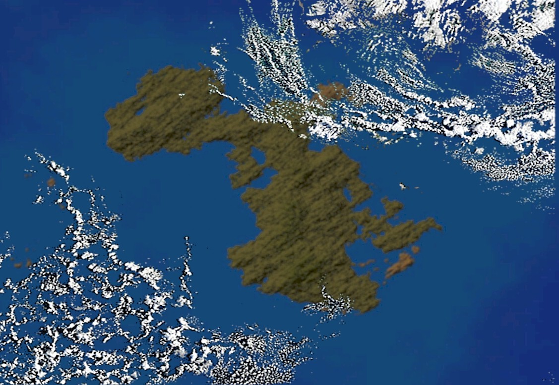
The Kingdom of Notia extends over 208,095 Square kilometers (80,346 square miles). It is bound on all sides by ocean. Most of the island consists of lightly wooded rolling hills meeting gentle beaches at the ocean. The South coast of Notia mostly consists of cliffs, hills and low mountains (the highest point being at 670 m or 2,200 ft). The interior of the country is relatively mountainous, traversed by rivers and many large lakes. The West-coast of the country is part of the vast watershed, containing large areas of bogland, used for peat extraction and production.
Climate
The climate of Notia is generally a mild Oceanic climate with few cases of extreme temperatures or storms. The highest temperature recorded was 91° F (33° C) in 1997 and the lowest temperature recorded was 0° F (-18° C) in 1881. The year-round average temperature for the kingdom ranges from 48° F (9° C) in the South to 59° F (15° C) in the North. The local temperate climate is relatively mild. Summer temperatures exceed 86 °F (30 °C) usually once every decade, though commonly reach 84 °F (29 °C) most summers, and freezes occasionally occur in winter, with temperatures below 21° F (-6 °C) being uncommon. Precipitation is very common, with some parts of the country getting up to 275 days with rain annually. Although there has been some evidence of climate change trending the islands to be warmer and wetter than their historical norms.
Geology
The oldest known Notional rock is about 1.8 billion years old. About 600 million years ago, at the end of the Precambrian era, the Notional landmass was divided into three parts. From the fossil evidence found, Notia was below sea level at that time. Over the next 160 million years, these three parts drifted towards each other, eventually uniting during the Silurian period, about 440 million years ago. Fossils discovered near Gopher Head show the coming together of shoreline fauna from all sides of the original dividing sea. The mountains of northwest Notia were formed during the collision, as was the granite found in locations along the interior of the island. The Notional landmass was then above sea level and lying near the equator. Fossil traces of land-based life survive from this period. These include fossilized trees, widespread bony fish and freshwater mussel fossils and the footprints of a four-footed amphibian preserved in slate on Vallorian Island. Between 400 million and 300 million years ago Notia sank beneath a calcium-rich warm sea. Coral reefs dominated these waters, eventually creating the limestone which makes up about 45 percent of the rock mantle of the island. As the waters receded, tropical forests and mangroves flourished. The resulting vegetable matter eventually formed coal. This period, known as the Carboniferous era, ended with further plate movement which saw Notia drift further Southward. The resulting pressure created those Notional mountain and hill ranges that run in a Northwest to Southeast direction. 250 million years ago much of the coal and sandstone were eroded. The thinner layers of limestone in the East of the island were also partially affected by this erosion. The limestone that was exposed by the loss of its sandstone mantle was affected by carbon dioxide and other factors resulting in a karstic landscape that can be seen in Arch-Duchy of Danskering. About 150 million years ago, Notia was again submerged in a warm calcite sea that resulted in the formation of chalk over large parts of the surface. Traces of this survive under the basalt lava that is found in parts of the North and Eastern portions of the islands. About 65 million years ago wide-spread volcanic activity began uplifting the mountains in the north of the island. The climate of the period was warm and dense vegetation thrived. Vegetable debris in the central island depressions formed deposits of brown coal which are an important part of the economy of the Arch-Duchy of Zealand. By 25 million years ago, a long period of erosion had resulted in considerable soil formation and most of the rock mantle was covered. In areas with good drainage, the covering consisted of dark brown soil while in poorly drained areas the black clay tended to dominate. As the climate cooled, soil formation slowed down, and a flora and fauna that would, millions of years later, be familiar to the first human inhabitants began to emerge. By about three million years ago, the present landscape of Notia had more or less formed. The highest point in Notia is 2200 feet (670 meters) above sea level. The average elevation of the Kingdom is 746 feet (225 meters) above sea level.